Remote Sensing Technology Market By Technology (Active Remote Sensing, Passive Remote Sensing) By Application (Agriculture & Living Resources, Military & Intelligence, Disaster Management, Infrastructure, Weather, Others) By Platform (Satellite, Aerial Systems) - Global Industry Analysis, Size, Share, Growth, Trends, Regional Analysis, and Forecast 2023-2031
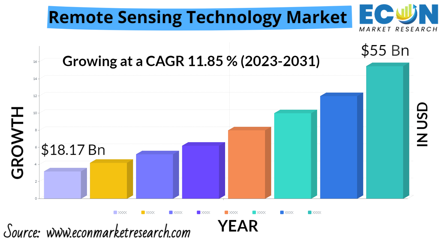
The global remote sensing technology market size was estimated at USD 18.17 billion in 2022 and is expected to hit around USD 55 billion by 2031, representing a CAGR of 11.85% from 2023 to 2031.
Remote sensing technology has various applications in different fields, and it has proven to be useful in improving crop management, monitoring forest cover and health, and identifying natural resources. In addition to what you mentioned, remote sensing technology is also used in many other areas. For example, it is used to monitor and predict weather patterns, which is critical for aviation, shipping, and other industries. Remote sensing can also be used to monitor air quality and detect pollutants, which is important for public health and environmental protection.
Furthermore, remote sensing technology is used for mapping and monitoring coastal areas, including changes in sea levels, ocean temperatures, and the spread of harmful algal blooms. This information is essential for understanding and mitigating the impacts of climate change.
Remote Sensing Technology Market Report Scope & Segmentation
|
Report Attribute |
Details |
|
Estimated Market Value (2022) |
18.17 Bn |
|
Projected Market Value (2031) |
55 Bn |
|
Base Year |
2022 |
|
Forecast Years |
2023 - 2031 |
|
Scope of the Report |
Historical and Forecast Trends, Industry Drivers and Constraints, Historical and Forecast Market Analysis by Segment- By Technology, By Platform, By Application & Region |
|
Segments Covered |
By Technology, By Platform, By Application & Region |
|
Forecast Units |
Value (USD Billion), and Volume (Units) |
|
Quantitative Units |
Revenue in USD million/billion and CAGR from 2023 to 2031 |
|
Regions Covered |
North America, Europe, Asia Pacific, Latin America, and Middle East & Africa, and Rest of World |
|
Countries Covered |
U.S., Canada, Mexico, U.K., Germany, France, Italy, Spain, China, India, Japan, South Korea, Brazil, Argentina, GCC Countries, and South Africa, among others |
|
Report Coverage |
Market growth drivers, restraints, opportunities, Porter’s five forces analysis, PEST analysis, value chain analysis, regulatory landscape, market attractiveness analysis by segments and region, company market share analysis, and COVID-19 impact analysis. |
|
Delivery Format |
Delivered as an attached PDF and Excel through email, according to the purchase option. |
Market Growth Factors:
The global market for remote sensing technology is expected to grow significantly in the coming years. One of the key drivers of this growth is the increasing demand for earth observation solutions, particularly from government agencies and organizations. Remote sensing technology has become an essential tool for various government applications, such as weather forecasting, disaster management, and environmental monitoring.
Another factor driving the growth of the remote sensing technology market is the growing emphasis on solving end-to-end remote sensing problems through a science and engineering approach. This approach involves integrating multiple data sources and applying advanced data analytics and machine learning algorithms to extract meaningful insights from the data.
Researchers at the Resilient Infrastructure and Disaster Response (RIDER) Center of the FAMU-FSU College of Engineering are working to develop better ways to predict areas for road-clogging after tropical cyclones using remote sensing data. This research is particularly relevant as remote sensing technology can provide valuable information for hurricane response and disaster management efforts.
By using remote sensing data to identify areas that are most susceptible to road-clogging after a tropical cyclone, emergency responders and disaster management teams can be better prepared to address the impact of the storm and minimize its effects on communities and infrastructure.
Market Dynamics
Market Drivers:
The use of remote sensing and geographic information systems (GIS) in environmental risk management is expanding rapidly
Remote sensing technology and GIS are powerful tools for spatial data analysis, mapping, and distribution. Recent advances in sensor design are revolutionizing the use of these technologies, making it possible to extract precise spatial data from satellite or aircraft images and analyze and manage this data using GIS. Remote sensing data can be used to measure a wide range of environmental variables, including land use, vegetation cover, water quality, and climate patterns. By integrating this data with other geospatial and demographic information, it is possible to create a comprehensive environmental database that can be used to monitor and manage natural resources and other critical systems.
Advanced image processing methods and algorithms are also making it possible to create these databases more quickly and efficiently than ever before, enabling faster and more accurate analysis of environmental data. This has the potential to revolutionize the way we understand and manage the Earth's natural systems, and to help us address some of the most pressing environmental challenges facing our planet today.
Remote sensing has the ability to enhance the resilience of the agriculture productions system. Modern agriculture is facing significant challenges that threaten the long-term economic and environmental sustainability of the food supply system. These challenges include the depletion of water and land resources, climate change, and high production costs, which have been exacerbated by the COVID-19 crisis. To address these challenges, scientific and technological advancements are needed to improve the efficiency and sustainability of agricultural practices. One promising area of innovation is the use of artificial intelligence (AI) and remote sensing technology to measure and analyze field-scaled phenotypic data.
Remote sensing technology can provide farmers with detailed information about crop health, soil moisture, and other environmental variables that affect crop growth and yield. This information can then be combined with AI-powered analytics to create more prescriptive and predictive management tools. By using these tools, farmers can make more informed decisions about planting, fertilization, irrigation, and other key aspects of agricultural management, which can lead to increased yields, improved resource efficiency, and reduced environmental impact.Overall, the combination of remote sensing and AI has the potential to revolutionize modern agriculture, enabling farmers to make more informed decisions and improve the sustainability and efficiency of the food supply system.
Market Challenges:
While the remote sensing technology market has experienced significant growth in recent years, there are several challenges that need to be addressed to sustain this growth in the future. Here are some of the major challenges:
Some of these challenges include:
High cost: The high cost is one of the major challenges in sustaining the growth of the remote sensing technology market. The initial investment required for developing and deploying remote sensing technology can be substantial, making it difficult for many organizations, especially small and medium-sized enterprises, to afford it.
Technical complexity: The technical complexity of remote sensing technology can be a challenge for non-experts who want to use the technology. This is because the technology requires expertise in areas such as data analysis, image processing, and GIS. To overcome this challenge, there is a need for user-friendly interfaces and tools that can simplify the technical complexity of remote sensing technology.
Data availability: In developing countries, limited infrastructure and funding can make it challenging to access and acquire remote sensing data. In addition, many developing countries may lack the technical expertise and resources required to process and analyze the data. This can create a significant barrier to entry for these countries, hindering their ability to fully utilize remote sensing technology for various applications such as disaster management, agriculture, and natural resource management.
Market Opportunities:
Precision agriculture, urban planning, disaster response, and climate monitoring are just a few of the new applications for remote sensing technology. As technology advances, new opportunities for growth in the market emerge.
Governments are investing more in remote sensing technology to support a variety of applications, including natural resource management, disaster response, and infrastructure planning. This investment opens up new avenues for remote sensing technology providers to provide services to government agencies.
Integration with AI and big data: By combining remote sensing technology with artificial intelligence and big data analytics, data processing and analysis can be improved, resulting in more accurate and timely insights. This opens up opportunities for providers of remote sensing technology to create new solutions that leverage AI and big data.
Segments Analysis:
Technology Insights:
Active remote sensing uses its own source of energy (such as radar or lidar) to detect and measure the properties of targets on the Earth's surface. This allows for measurements to be made at any time of day or night, and in all weather conditions, which is particularly useful for applications such as monitoring changes in sea ice or detecting forest fires at night.
Application Insights:
It's worth noting that while the military and intelligence sectors have traditionally been major users of remote sensing technology, the market is also seeing significant growth in other industries such as agriculture, forestry, mining, and environmental monitoring. These sectors are increasingly using remote sensing technology to improve their operations and decision-making processes. Additionally, there is a growing trend towards the use of commercial satellite imagery in industries such as insurance, finance, and real estate, which is expected to further drive the growth of the remote sensing technology market.
Platform Insights:
The growing demand for drones in various applications, such as agriculture, mining, and construction, is also driving the growth of the aerial systems segment in the remote sensing technology market. The satellite systems segment also holds a significant share in the market, and it is expected to continue to grow due to the increasing demand for high-resolution satellite images for various applications such as urban planning, disaster management, and defense.
Regional Analysis:
North America has a well-established market for remote sensing technology, and the presence of major players in this region is expected to drive the growth of the market. The use of remote sensing technology in precision agriculture is a significant factor contributing to the growth of the market in North America. With the increasing need for sustainable agriculture practices, the adoption of remote sensing technology can help water resource managers and farmers to make informed decisions and optimize crop yields while conserving water resources. This, in turn, is likely to drive the demand for remote sensing technology in the region.
The Asia-Pacific region has been witnessing significant growth in the adoption of remote sensing technology for various applications, including agriculture, environmental monitoring, and disaster management. The region has also been investing in satellite technology and earth observation capabilities to support infrastructure development and achieve sustainable growth. The increasing demand for accurate and timely geospatial data in the region is expected to drive the growth of the remote sensing technology market over the next decade.
Competitive Landscape
The Global Remote Sensing Technology Market Some of the major companies include: -
Key Market Players:
Remote Sensing Technology Market Report Segmentation
|
ATTRIBUTE |
DETAILS |
|
By Technology |
|
|
By Application |
|
|
By Platform |
|
|
By Geography |
|
|
Customization Scope |
|
|
Pricing |
|
Key Benefits of the Report
Research Methodology
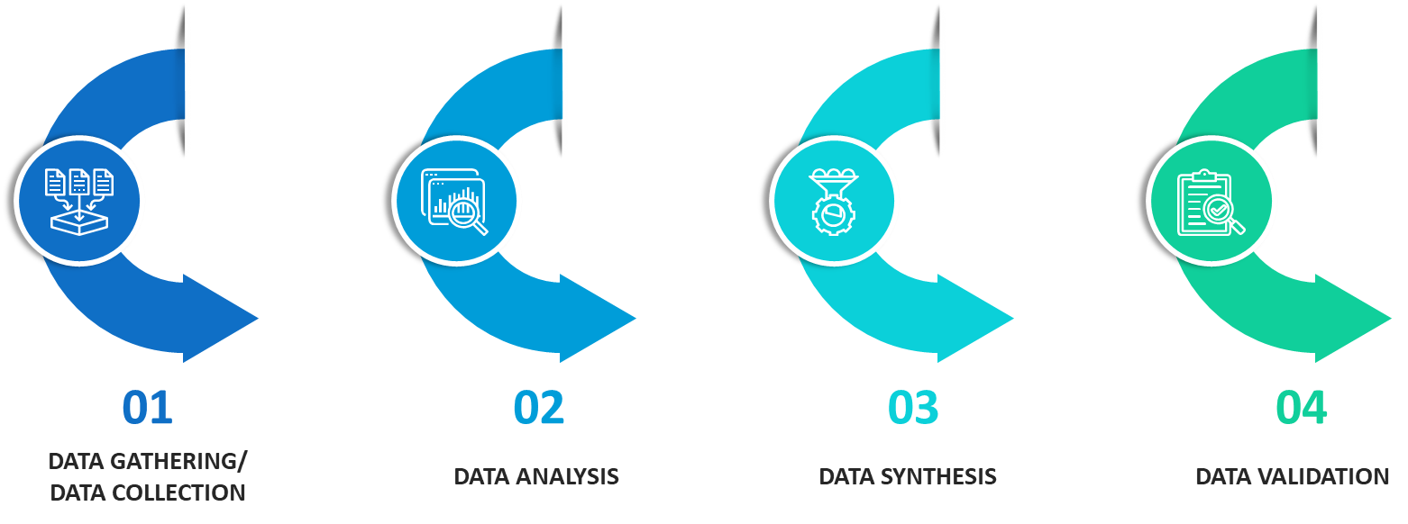
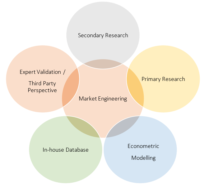
Our research methodology has always been the key differentiating reason which sets us apart in comparison from the competing organizations in the industry. Our organization believes in consistency along with quality and establishing a new level with every new report we generate; our methods are acclaimed and the data/information inside the report is coveted. Our research methodology involves a combination of primary and secondary research methods. Data procurement is one of the most extensive stages in our research process. Our organization helps in assisting the clients to find the opportunities by examining the market across the globe coupled with providing economic statistics for each and every region. The reports generated and published are based on primary & secondary research. In secondary research, we gather data for global Market through white papers, case studies, blogs, reference customers, news, articles, press releases, white papers, and research studies. We also have our paid data applications which includes hoovers, Bloomberg business week, Avention, and others.
Data Collection
Data collection is the process of gathering, measuring, and analyzing accurate and relevant data from a variety of sources to analyze market and forecast trends. Raw market data is obtained on a broad front. Data is continuously extracted and filtered to ensure only validated and authenticated sources are considered. Data is mined from a varied host of sources including secondary and primary sources.
Primary Research
After the secondary research process, we initiate the primary research phase in which we interact with companies operating within the market space. We interact with related industries to understand the factors that can drive or hamper a market. Exhaustive primary interviews are conducted. Various sources from both the supply and demand sides are interviewed to obtain qualitative and quantitative information for a report which includes suppliers, product providers, domain experts, CEOs, vice presidents, marketing & sales directors, Type & innovation directors, and related key executives from various key companies to ensure a holistic and unbiased picture of the market.
Secondary Research
A secondary research process is conducted to identify and collect information useful for the extensive, technical, market-oriented, and comprehensive study of the market. Secondary sources include published market studies, competitive information, white papers, analyst reports, government agencies, industry and trade associations, media sources, chambers of commerce, newsletters, trade publications, magazines, Bloomberg BusinessWeek, Factiva, D&B, annual reports, company house documents, investor presentations, articles, journals, blogs, and SEC filings of companies, newspapers, and so on. We have assigned weights to these parameters and quantified their market impacts using the weighted average analysis to derive the expected market growth rate.
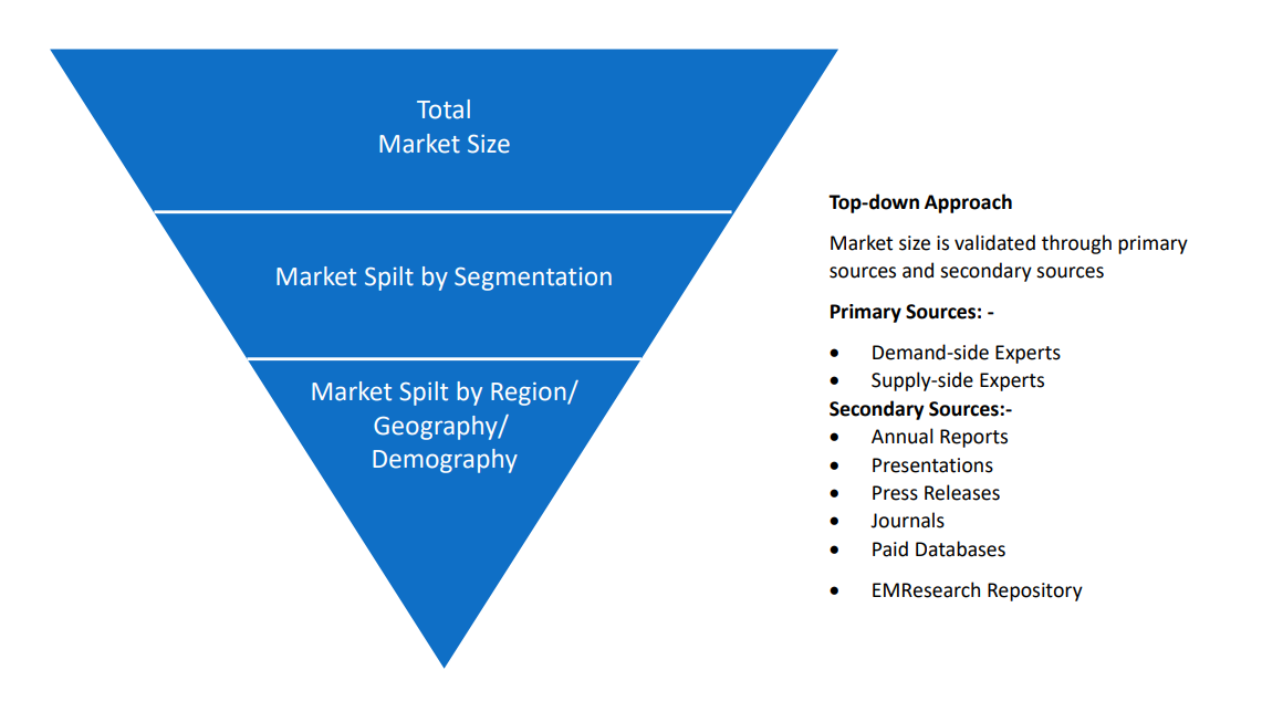
Top-Down Approach & Bottom-Up Approach
In the top – down approach, the Global Batteries for Solar Energy Storage Market was further divided into various segments on the basis of the percentage share of each segment. This approach helped in arriving at the market size of each segment globally. The segments market size was further broken down in the regional market size of each segment and sub-segments. The sub-segments were further broken down to country level market. The market size arrived using this approach was then crosschecked with the market size arrived by using bottom-up approach.
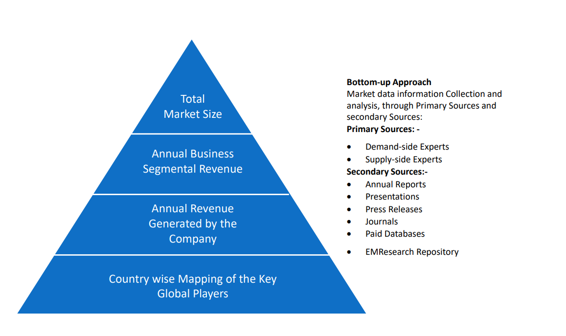
In the bottom-up approach, we arrived at the country market size by identifying the revenues and market shares of the key market players. The country market sizes then were added up to arrive at regional market size of the decorated apparel, which eventually added up to arrive at global market size.
This is one of the most reliable methods as the information is directly obtained from the key players in the market and is based on the primary interviews from the key opinion leaders associated with the firms considered in the research. Furthermore, the data obtained from the company sources and the primary respondents was validated through secondary sources including government publications and Bloomberg.
Market Analysis & size Estimation
Post the data mining stage, we gather our findings and analyze them, filtering out relevant insights. These are evaluated across research teams and industry experts. All this data is collected and evaluated by our analysts. The key players in the industry or markets are identified through extensive primary and secondary research. All percentage share splits, and breakdowns have been determined using secondary sources and verified through primary sources. The market size, in terms of value and volume, is determined through primary and secondary research processes, and forecasting models including the time series model, econometric model, judgmental forecasting model, the Delphi method, among Flywheel Energy Storage. Gathered information for market analysis, competitive landscape, growth trends, product development, and pricing trends is fed into the model and analyzed simultaneously.
Quality Checking & Final Review
The analysis done by the research team is further reviewed to check for the accuracy of the data provided to ensure the clients’ requirements. This approach provides essential checks and balances which facilitate the production of quality data. This Type of revision was done in two phases for the authenticity of the data and negligible errors in the report. After quality checking, the report is reviewed to look after the presentation, Type and to recheck if all the requirements of the clients were addressed.